
|
|
|
|
Overview |
|||
| [Home] [Overview] [Architecture] [Scenario] [People] [Publications] | |||
(TIERRA)
|
|
|
|
|
Overview |
|||
| [Home] [Overview] [Architecture] [Scenario] [People] [Publications] | |||
|
|
Computational Science Overview |
|
|
Geoscience Overview |
|
|
Geophysics Background |
 N.
N.
Geoscience Overview
In the Department of Geological Sciences at the University of Oregon, we are studying ocean ridge volcanic systems to determine quantitative constraints on their magmatic and heat fluxes. Because ocean ridges and their interiors are inaccessible to direct study, remote sensing techniques are used. Seismic tomography allows a sampling of the Earth's interior via earthquake or human-made pressure waves recorded by seismic instruments. Just as X-rays are sensitive to density variations of organic tissue, seismic waves are sensitive to density variations of rock. This principle (similar to that used in medical CAT scans) can be used to determine the three-dimensional structure of the Earth's interior. Seismic tomography thus allows geophysicists to image volcanic systems and predict how the heat and magma distribution correlates with surface processes (e.g. hydrothermal activity) or to image the mantle in search of the roots of volcanoes.
We still do not understand many of the basic mechanisms that control ridge processes. First, how is melt delivered from the asthenosphere to the surface, in discrete plumes or in a rising sheet? Second, what is the distribution and storage of magma in the crust at fast- and slow-spreading ridges? Third, what is the depth of sea water penetration and cooling of the cracked crust, and how does it affect the strength of the plate? Last, what is the extent of faulting and how does it accommodate local stress fields? Understanding the interaction of these four mechanisms will be crucial in producing a self consistent model of mid-ocean ridge processes.
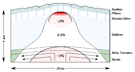
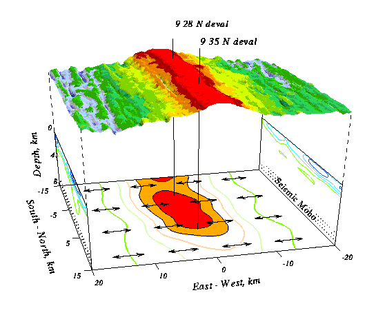
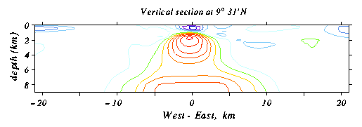
Determining the seismic velocity structure of the ridge and its roots is a direct path to exploring its magmatic, hydrothermal, and tectonic processes. Seismic velocities, which are especially sensitive to anisotropy, high temperatures, and the presence of partial melt, can be used to determine the distribution of strain, temperature and melt within the crust and mantle. At slow-spreading centers, where the thermal structure is cooler and magma chambers are less likely to exist, variations in porosity caused by cracking and the circulation of seawater have a large influence on the seismic velocities.
Tomography has been used to image the velocity structure of the crust at both fast- and slow-spreading ridges. Seismic receivers, placed on the seafloor, record acoustic energy from sources on the surface. The energy propagates downwards from the surface into the crust, where it is then refracted back to the surface by the positive velocity gradient of the crust. The travel time of the seismic wave from source to receiver depends on the velocities sampled by the wave along its path. Travel-time data is the primary information we use to determine the velocity structure of the crust. Many different ray paths and travel-times can be inverted to find the velocity structure (see image below).
Mapping travel-times to velocity structure requires two stages. The first is ray tracing, which calculates synthetic travel-times and ray-paths for a starting velocity model. For this we use a shortest-path ray tracing algorithm which exploits Fermat's principle of shortest time. The second stage, the inversion, perturbs the velocity structure to best match the observations. Several iterations of these two stages are required to produce a final velocity model.